


- 4:15 h
- 12.85 km
- 566 m
- 505 m
- 1,924 m
- 2,333 m
- 409 m
- Start: Bettmeralp, top station of aerial cable car
- Destination: Bettmeralp, valley station of the Bettmerhorn gondola
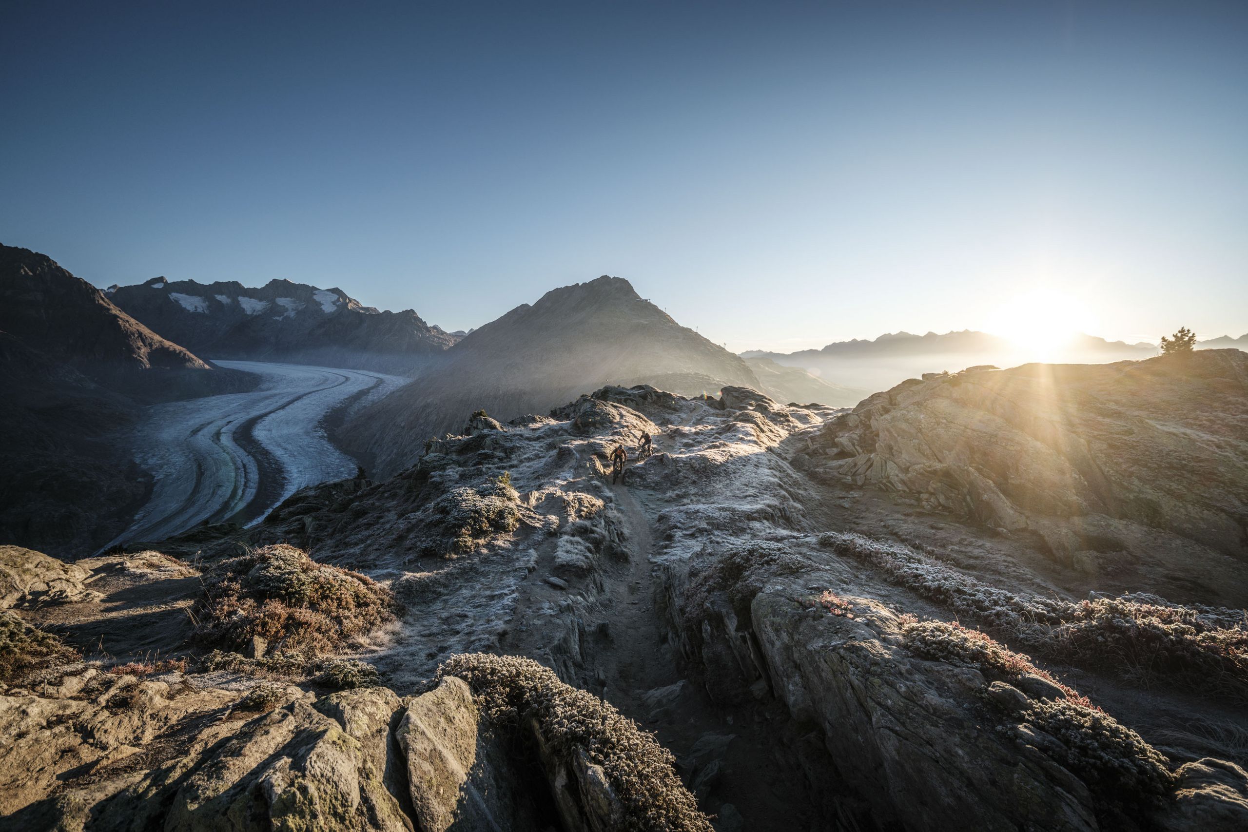
The first section takes you from Bettmeralp up to Lake Bettmersee and along the western shore to the turnoff towards Gopplerlücke. Follow the Herrenweg to Berghaus Toni (Riederalp West). Then it’s uphill to Riederfurka, where it’s recommended to visit the Pro Natura Centre Aletsch at Villa Cassel. Well-informed about Aletsch Forest and the UNESCO World Heritage Site, you head from Riederfurka along the Moraine Trail through the protected Aletsch Forest. After about 30 minutes, the view opens up on the imposing Great Aletsch Glacier. Passing centuries-old Swiss stone pines, you continue on towards Moosfluh and Biel. Here you switch to the side of the sunny plateau and tackle the last stage of the hike, the downhill walk to Lake Bettmersee and Bettmeralp.
Important: Aletsch Forest has been under strict nature protection since 1933 – please follow the rules displayed on signs there!


Good to know
Best to visit
Directions
Tour information
Cultural Interesting
Loop Road
Stop at an Inn
Equipment
We recommend:
- good footwear
- clothing suitable for the weather: always carry a waterproof jacket
- hat or cap
- sunscreen
- bottle for water
- picnic
- camera
- binoculars (optional)
- hiking poles (optional)
- printout of this hike (click «Print» icon, to download)
Directions & Parking facilities
Additional information
Aletsch Arena AG
Furkastrasse 39
CH-3983 Mörel-Filet
+41 27 928 58 58
info@aletscharena.ch
www.aletscharena.ch
Literature
Author´s Tip / Recommendation of the author
Safety guidelines
Use of the trails and the information on this website is at hikers’ own risk. Local conditions may entail changes to routes. Aletsch Arena AG accepts no liability for the accuracy and completeness of information on this website.
- Bring a map. Download full description of this route including large-scale map by clicking on «Print» icon, top right of this page.
- Use marked trails only, and observe all signposting – for your own safety, to safeguard grazing animals and to avoid disturbing wildlife.
- Close gates after passing through.
- Please be considerate to other trail users, and to the plants and animals.
- Do not leave any waste in nature.
Map
Nearby


